First, a quick recap of Transit-Oriented Communities: created upon voter approval of Measure JJJ in December 2016, the program grants generous density bonuses, decreases parking requirements, and speeds up permitting for multifamily housing projects within a half-mile of transit, as long as they allocate a share of new units to lower-income households at a rent they can afford. Less than two years later, the LA City Council also approved the Exposition Corridor Transit Neighborhood Plan(TNP) that rezoned 256 acres along the Expo E Line that could enable another 6,000 homes to be built by 2035. The plan has been subjected to a lawsuit from Fix the City, which is ongoing; although it was indeed implemented in December 2019.
These programs were positive steps in the right direction, but the Westside needs leaps and bounds to realize visions of a walkable, affordable community. Abundant Housing LA is reporting on the housing situations near four Westside Expo E Line stations, and this is the third installment of the blog series. Read the first post here. You’ll see what’s changed since these two pro-housing policies went into effect, as well as what’s holding back these neighborhoods from being everything they can be.
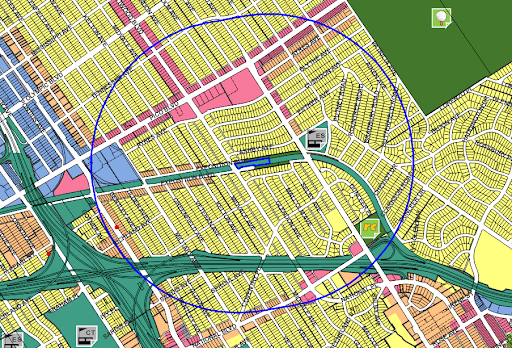
Study area: a half-mile around Westwood/Rancho Park rail station
In our previous entry about development opportunities along the Los Angeles E line, you read about how small zoning changes could create hundreds of new homes near the Expo/Bundy and Expo/Sepulveda stations. Now we’re moving further east to Westwood/Rancho Park station, where zoning policies are preventing the surrounding neighborhood from being a true transit-oriented community.
What you’ll see within 0.5 miles: In short, a lot of single-family homes. We identified plentiful opportunities for denser, more sustainable growth around the nearby Expo/Sepulveda station, but the potential around this station is even greater. On the north side of the light rail line is the Westwood Neighborhood Greenway, which opened this past January. Planted with native vegetation and equipped with water pumps to facilitate runoff filtration, the park also has a walking path parallel to the rails. On the south side of the train station is the Exposition Corridor Bike Path. These open spaces improve the pedestrian experience, especially critical since the station has no designated parking nearby.
These two public spaces, as well as the rail station, could serve many more Angelenos than they currently do, because the vast majority of the blocks surrounding them are zoned exclusively for one-family dwellings. What’s more, few of these homeowners seem to have equipped their backyards or garages with accessory dwelling units. Even the busy five-lane Westwood Boulevard is flanked by ranch homes with two-car garages in the back. Moreover, these homes are currently selling for north of $1 million, far out of reach for the average Angeleno.
On the north end of Westwood, just barely within the station’s half-mile radius, is a small strip of one- and two-story commercial buildings that house businesses such as a butcher, a pharmacy, a few casual restaurants, and some specialty shops. Further south, Pico Boulevard represents the primary commercial area for this neighborhood. It hosts several banks, locally-owned restaurants, and a music store. On the south side of Pico sits Westside Pavilion, a dead shopping mall that now hosts only a large movie theater. South of the 10 freeway along Sepulveda are a few multifamily units just within walking distance of the Metro. One was completed in 2018 and contains 25 apartments; it was made possible thanks to the density bonus program and hosts two very-low-income units and 1 low-income unit.
What’s coming: On the commercial side, the aforementioned dead Westside Pavilion mall is being converted into 230,000 square feet of offices, which Google will reportedly lease. With easy access to the E line and Exposition bike path, this property should prove to be highly desirable for workers looking to avoid traffic and reduce their carbon footprint. The project also preserves the 1,500 parking spaces needed for the mall, however, so workers won’t have much difficulty defaulting to a car commute.
In terms of residential development, some changes are on the horizon. Upcoming projects include:
- 10608 W. Pico: currently a strip of one-story retail shops, a builder has applied to build 50 units of housing atop almost 6,000 square feet of ground-floor commercial space. Through the Transit Oriented Communities program, they have requested to build at a greater density than otherwise allowed in exchange for setting aside five apartments for extremely low-income households.
- 2336 Westwood: This once-vacant lot is being transformed into a three-story, 23-home apartment building. Given its smaller size and location on a commercially zoned parcel, it seems unlikely that the developer took advantage of any incentives.
Help support our work! Become a member today.
What should happen: Opportunities abound around Westwood/Rancho Park Station. With the right zoning changes, many more people could call this area home and benefit from its parks, shopping and transit access.
Let’s start with the lowest-hanging fruit: four city-owned parking lots within a half-mile of the station. The largest one, which can hold 41 cars, is right across the street from the large Westside Pavilion parking deck. This represents needless duplication of parking, especially in an area well-served by public transportation. The city of LA could easily rezone these parcels to multi-family residential and sell them to homebuilders, quickly adding much-needed housing to this area. Builders could take advantage of AB 1763 to construct additional units beyond what would be permitted by typical multifamily zoning in exchange for designating a portion of them as affordable to low- or moderate-income households.
Further zoning changes could create more working and housing options along the two primary commercial corridors, Westwood Blvd. and Pico Blvd. With the exception of Westside Pavilion, single-story commercial buildings and strip malls predominate. Leaders could rezone these lots and the R-1 ones behind them to allow higher-density, mixed-use development like what we see just down the road at Linea. Other parcels could host offices, so that more nearby residents could avoid the 10 freeway and walk to work.
Additionally, the large swathes of single-family lots should be upzoned. While SB 9 and 10 can help densify the Rancho Park and Cheviot Hills neighborhoods, it is unlikely that residents will take advantage of their property’s full potential. Building on this irony, single-family homes currently surround the Metro station, meaning that such proximity benefits only a few select people. Rezoning these plentiful R-1 plots to permit multi-family housing would allow the Transit-Oriented Communities program to apply, allowing much-needed density to be added to this area.
Sign up to help reform housing!


